Logo

Success Story Details

Smart Farming: Sugarcane Plant Annotations at Scale
sugarcane annotationagriculture AIcrop detectionaerial image annotation

Smart Farming: Sugarcane Plant Annotations at Scale

Project Background

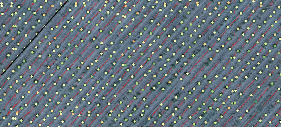
In the rapidly evolving field of precision agriculture, accurate data labeling plays a critical role in building computer vision models that can detect crops, optimize yield, and reduce human error. Our client, an AI-focused agritech organization, approached us with a highly specialized requirement: detecting individual sugarcane plants from drone-captured imagery of vast sugarcane fields.

These drone images offered a bird’s-eye view of large plantations, where sugarcane seedlings were aligned in long, repetitive rows. While this format was ideal for aerial inspection, it posed unique challenges for annotation and machine learning.

Client Requirements

The core objectives of the project were:

  • Bounding Box Annotation: Each individual sugarcane seedling had to be precisely enclosed in a bounding box.
  • Spatial Relationship Mapping: The relative distance between adjacent seedlings had to be visually represented using line annotations.
  • Large-Scale Dataset Preparation: The dataset contained tens of thousands of high-resolution images, requiring annotation of millions of small objects.
  • Custom Annotation Workflow: The client required a workflow that ensured data quality, consistency, and review cycles, all within a tight timeline.

Key Challenges We Faced

The project demanded not only technical precision but also creative problem-solving. Here are the major hurdles we had to overcome:

  1. Tiny and Indistinct Objects: Because the images were captured from high altitudes, the sugarcane seedlings appeared very small, blurry, and low in contrast. Standard object detection tools often failed to detect these seedlings.
  2. Low Visibility in Natural Lighting: Lighting conditions varied widely across different regions and times of day. Shadows, uneven exposure, and soil textures made some seedlings nearly invisible to the naked eye.
  3. Similar-Looking Background: The sugarcane seedlings were surrounded by soil, weeds, and shadows—all of which appeared visually similar in aerial view. This led to a high risk of false positives or missed detections.
  4. Row Alignment MappingVolume and Turnaround: The spatial relationship between seedlings had to be clearly marked using lines—an uncommon requirement in agricultural annotation, especially at this scale.
  5. Volume and Turnaround: Millions of individual annotations had to be made, reviewed, and finalized in a limited time without compromising accuracy or consistency.

Our Approach & Solution

To deliver high-quality annotation within the project scope and timeline, we adopted a structured, scalable, and highly customized workflow:

1. Tooling Innovation

We designed and deployed a custom annotation tool tailored to high-resolution aerial images. This tool allowed zoom-level control, annotation snapping, and automated duplication of bounding boxes across similar areas—vastly improving productivity.

2. Specialized Training for Annotators

Our team underwent a domain-specific training session focused on identifying sugarcane patterns, distinguishing them from weeds, and understanding row structures.

3. Multi-Layered QA Process

We implemented a 3-tier quality assurance system:

  • Layer 1: Manual cross-checking of every 10th image by a lead annotator.
  • Layer 2: Automated consistency checks for overlapping bounding boxes or spacing anomalies.
  • Layer 3: Final dataset validation against a gold-standard subset provided by the client.

4. Scalable Workforce Management

We assembled a specialist annotation team from our agriculture domain unit, working in rotating shifts to ensure 24/7 progress tracking and faster throughput.

Results & Impact

Despite the complexity of the task, our team successfully delivered:

  • 1.2 million+ bounding box annotations
  • 1.2 million+ row alignment lines
  • 99.2% accuracy rate verified via QA sampling
  • 100% on-time delivery, ahead of the client’s ML model development cycle
  • Zero rework requests, indicating high satisfaction from the client’s ML team

Outcome for the Client

The annotated dataset we delivered enabled the client to:

  • Train a high-performing computer vision model to detect sugarcane plants from real-world aerial drone footage.
  • Automatically calculate row spacing, detect planting inconsistencies, and plan yield optimizations.
  • Move forward with a scalable AI pipeline for other crops and regions.

As a result, the client expanded their use case across multiple crops and continued collaboration with Intellisane AI for new annotation tasks in agriculture and beyond.

Client Feedback

“The Intellisane AI team exceeded our expectations. Their ability to quickly adapt to the nuances of agricultural annotation, coupled with their quality assurance process, made them a valuable partner in our AI pipeline.”

Share This Post:

Related Articles

AI-Powered Volleyball Player and Ball Tracking | Intellisane AI Success Story
Sports AnalyticsBall DetectionVideo AnnotationVolleyball AI

AI-Powered Volleyball Player and Ball Tracki...

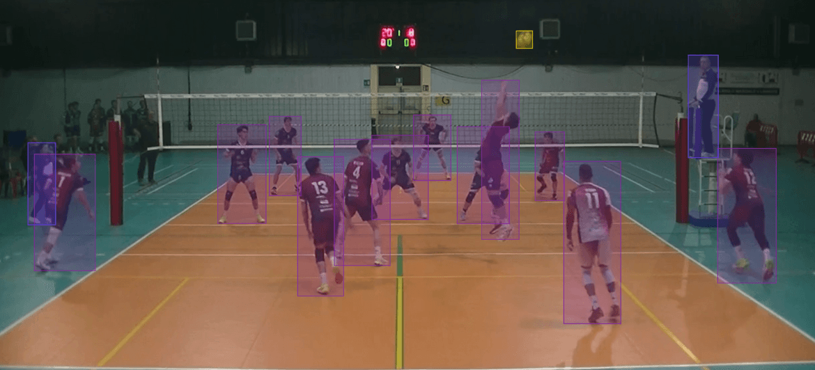
Intellisane AI achieved 98.7% accuracy in volleyball player and ball tracking by annotating over 100,000 bounding boxes in match videos for sports analytics.

Smart Farming: Sugarcane Plant Annotations at Scale
sugarcane annotationagriculture AIcrop detectionaerial image annotation

Smart Farming: Sugarcane Plant Annotations a...

Discover how Intellisane AI successfully annotated over 4.8 million sugarcane plants from drone imagery using custom tools, enabling high-accuracy AI for smart agriculture.